Showing posts with label I Vortext Highlights. Show all posts

Saturday

Last Daze at Trump University: Confessions of a Donald Trump Ghostwriter


I was known as the "Voice of Trump”—writing a blog under his name. It was the Donald’s first online presence, in 2005—at the dawn of social media, before Twitter and the smart phone; before “birtherism” and the financial crisis, when The Apprentice was at peak popularity (a more innocent time, to say the least). 

To become the Voice of Trump I had to summon the spirit of the man; I had to channel the Donald…I made my office a shrine to my job as mouthpiece for this titan of kitsch, this mogul of tawdry rhetorical baubles.

Read the article on Vox:

Watch for the upcoming book—a monumental memoir/exposé cum history of political media…in the tradition of All the President’s Tweets.


Donald Trump: Showman of the Skyline...


Colossus of New York...


Straddling the buildings that bear his name...


His signature branded upon the cityscape.


Last daze at Trump (it was all a blur)


Leaving Trump (marble lobby)

Wednesday

Braddock (Slideshow)


An old steel town of ragged charms 


Braddock

Full Screen – Click on: Picture > 2-way arrows (top right) 


For more slideshows visit:

Monday

The East Busway’s Singular Lens on Pittsburgh


Pittsburgh’s Martin Luther King Jr. East Busway is a distinctly local specimen of infrastructure, and a true urban curiosity. The 9.1 mile stretch lies in a hollow, next to the railroad.

The East Busway, now 30 years old, was the first buses only roadway in the U.S., and a pioneer in the Bus Rapid Transit movement. To travel the whole route—downtown to Swissvale—takes a mere 20 minutes; at rush hour buses run every two minutes. The sights go by fast for commuters, as they’re whisked home at night and to work in the morning.

But the hollow is a singular place, where nature and industry converge dramatically; to walk the hollow, on the tracks beside the busway, is to get a rare look at the city’s unique topography. (For more on this, see my article in the winter 2014 issue of Pittsburgh Quarterly, Voyaging through the Hollow: The East Busway’s Singular Lens on Pittsburgh.)


Houses next to busway (Shadyside)

Satellite Map (Imagery & Map data ©2013 Google -) . . . Street View (© 2013 Google)


The route (map courtesy of Port Authority of Allegheny County) [Click to enlarge]


Classic Pittsburgh: Houses layered in the hillside


Satellite image of busway (from Baum & Morewood to Herron & Liberty) [Click to enlarge]

Satellite Map (Imagery © 2013 DigitalGlobe, Sanborn, U.S. Geol. Survey, USDA Farm Svc. Agency; Map Data © 2013 Google.)


Zooming through the hollow at rush hour, the hills draped in a pall of greenery (vestiges of the woodlands it once was)


The path is diverse—encompassing nature & office buildings, historic landmarks, parking garages, assorted detritus, and more.


Out of the shadows, turning the curve . . . a kinetic corridor (Baum Blvd., Centre Ave. bridges)

Satellite Map (Imagery ©2013 DigitalGlobe, Sanborn, U.S. Geol. Survey, USDA Farm Svc. Agency; Map data ©2013 Google)


Houses in Bloomfield—end of the road, almost under Millvale Ave. Bridge

Satellite Map (Imagery & Map data ©2013 Google) . . . Street View (© 2013 Google)


The busway passes under spans of all types, from modest little footbridges to the monolithic Bloomfield Bridge.

Satellite Map (Imagery ©2013 DigitalGlobe, Sanborn, U.S. Geol. Survey, USDA Farm Svc. Agency; Map data ©2013 Google) . . . Street View (©2013 Google)


A row of old, camouflaged houses sits above the Neville Ramp—a living relic from before the busway came through (all but consuming their front yards & fencing off the horizon).

Satellite Map (Imagery & Map Data ©2013 Google)


The Neville Ramp—implanted in the hillside (under Baum Blvd.)

Satellite Map (Imagery & Map Data © 2013 Google)


Where topography and infrastructure meet, the essence of the city is revealed.


The ramp exits onto Centre Ave. in Oakland, demonstrating the busway’s versatility—using aspects of both rail & bus transit.


The Neville Ramp is 1,800 feet long. Its foundation includes 12 “hammerhead” piers, which sit atop either steel piles or caissons—24” to 30” diameter holes which are drilled down to solid rock and filled with reinforced concrete—depending on the geologic condition found at each footing location. The foundation is composed of about 24 million pounds of concrete; while the deck contains 9.2 million pounds. The ramp’s deck and foundation together contain more than three million pounds of steel.

This information comes from Norman Voigt, a retired civil engineer who spent 25 years with the Port Authority of Allegheny County (PAT) and was instrumental in developing the ramp.

The preliminary work required for the project included “core boring,” as part of an extensive geotechnical study. For core boring 2.5” diameter holes were drilled in multiple spots along the ramp’s footprint, then geologists analyzed the rock samples found on the drill bit at various depths, to determine the kind of material present there. This allowed them to draw a profile of the whole area—re-creating unseen layers where necessary; then they could determine where exactly to lay the foundation.

"Ten to 20 feet below the surface you get to hard, shale-like rock formations; then you run into coal seams, then sea bottom—with seashells and the like; then you hit limestone and sandstone,” said Voigt. “There are many problems with building on shale, mostly in that it’s not as hard as limestone or sandstone, which is why large foundations are usually dug down deeper.”


Telltale scraps, in the weeds around the tracks . . . Passing through the industrial corridor


Paw of industry (scooping up the light)


Herron Ave. Station (nr. Liberty Ave. & 33rd St.) . . . Next stop: Downtown

Satellite Map (Imagery ©2013 DigitalGlobe, Sanborn, U.S. Geol. Survey, USDA Farm Svc. Agency; Map data ©2013 Google) . . . Street View (©2013 Google)

Thursday

A Shrine in South Oakland (Slideshow)

Shrine of the Blessed Mother on Wakefield Street


Full Screen: ► . . . 4-way arrows (lower rt.)


For more slideshows visit:
Images of Pittsburgh on Flickr


Monday

Exile in America (Part 3): Lawrenceville/Strip District

After 25 years in New York, the author moves back to his hometown and discovers a new world lodged in the old one . . . Sometimes the strangest destination is home.


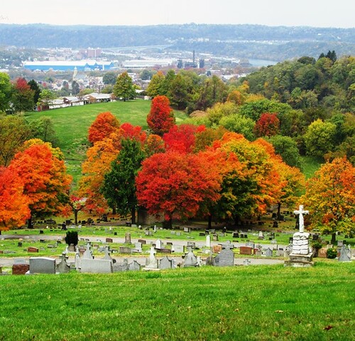
Stephen Foster’s tombstone, Allegheny Cemetery

A most nondescript monument for such an iconic figure (and native son). But it may be fitting, for even though Foster wrote some of the most popular songs ever — songs I sang in grade school music classes, that are still lodged in my head — he died on the Bowery, drunk and destitute.


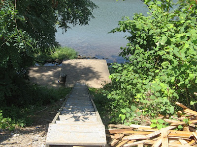
Down to the waterfront (satellite image)


Gingerly I walked the narrow shoreline, hearing explosions up ahead. I encountered a group of shirtless urchins, setting off fireworks, doing what urchins do. “Just passing through,” I declared. Lord of the Flies occurred to me then — primal regression, at society’s edge; a vision of being swarmed, having my throat cut and left for dead. (I don’t think they were the type, though, and surely I didn’t deserve it, for my harmless intrusion on their obscure hideaway.)


“Bad Kids . . . Spunk”


Houses in Lawrenceville

Lawrenceville has undergone a renaissance in recent years, through the same "mixed use" formula that's driving the revival of neighborhoods across the Rust Belt. It’s the antithesis of suburbia: instead of houses in one place, the shopping mall in another, and industry segregated in some no-go hellscape, it's all intermixed. When it works, as it does here, it’s a vivid, concrete expression of vitality.


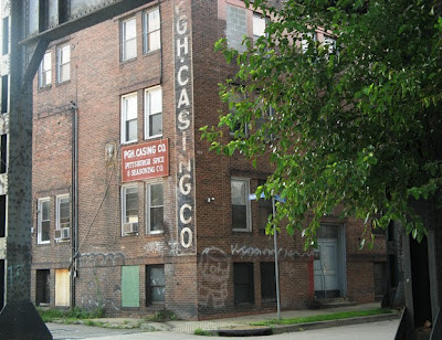
Pgh. Casing Co., Strip District (next to 33rd Street Bridge)


My band used to rehearse here; the guitarist’s father owned the company, which made natural sausage casings. I most remember the drying room upstairs, a large space filled with racks where pig intestines were stretched out on slats, and that smell — like walking into the belly of a pig.


Former site of 27 Bar, a dive my grandmother owned for 20 years(then sold to the city, which cleared the property a long time ago)


One of the wholesale candy stores my uncles owned (17th St. & Penn Ave.) . . . My cousin took over the business (this store and the main one in Mt. Oliver are still operating).

Exile in America (Parts 1-4)

More Images of Pittsburgh (Slideshows)

Sunday

Exile in America (Part 4): Troy Hill/Spring Garden/North Side

After 25 years in New York, the author moves back to his hometown and discovers a new world lodged in the old one . . . Sometimes the strangest destination is home.


Real Pittsburghers don’t cross bridges, they say, meaning people stay in their own self-contained enclaves.* That was true for me growing up. Those cross-river neighborhoods might as well have been two or three states away. The North Side, for example, was alien territory surrounding Three Rivers Stadium, where I ventured occasionally to see my beloved Pirates play, retreating back to familiar ground immediately after the game.

Some months after moving back to Pittsburgh, I got a temp job that took me north, to Spring Garden/Troy Hill, writing copy for a flight simulator company. Something about the area, which I had never even been near, fascinated me. Every smoky vista and perilous concrete staircase illustrated the convergence of location and destiny, and how a different neighborhood in the same city is really another world.

*That’s also true for Brooklyn, as well as other cities pocked with diverse and far-flung neighborhoods.


Parking lot of the flight simulator company where I worked


The staircase I used during my job – down in the AM, up at night (photo taken winter 2013)


Another look at the same staircase (summer 2013)
 

Troy Hill, probably more than anyplace in the city, is hostage to the hills – separated from the surrounding neighborhoods (and even from itself) by elevation, and the inaccessibilites that come with building/destroying/rebuilding all over such difficult terrain. Also, it doesn’t help that the neighborhood’s only direct link to the waterfront, arterial roads, and the other side of town –  Rialto St./31st Street Bridge – is under construction and will remain unusable for at least another 18 months. Such isolation gives the neighborhood an intimate feel, and makes those familiar staircases truly essential for basic navigation.

 
Houses through tree cover, the neighborhood glows


No easy way down . . . Some old staircases demand full attention.


The final stretch – a crooked landing


Terminus for an epic staircase – the aptly named Basin St. (nr. Spring Garden Rd.)


Staircases raking the hillsides . . . Classic Pittsburgh: Taming nature with industry


Where the locals gather (to elevate the mood)


Heinz Factory smokestacks – the neighborhood’s dominant view (esp. from Troy Hill Rd.)


Gateway to the north: 16th Street Bridge


Andy’s relative, a long-time scrap dealer


Slag pot from steel mill beside viaduct (industry as artifact)


Ivy covered stanchion: A part of the skyline (9th Street Bridge)


Exile in America (Parts 1-4)

More Images of Pittsburgh (Slideshows)